


Trackbook GPS

Deskripsi Trackbook GPS
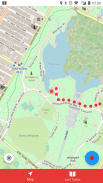
Trackbook is a bare bones app for recording your movements. Trackbook is great for hiking, vacation or workout. Once started it traces your movements on a map. The map data is provided by OpenStreetMap (OSM).
Trackbook is free software. You can find the code on GitHub (https://github.com/y20k/trackbook). GitHub is also a good place to file bugs or even to contribute, if you are interested. Trackbook is published under the MIT open source license. Trackbook uses osmdroid to display the map, which is also free software published under the Apache License.
HOW TO USE TRACKBOOK
+ Start recording movements
Press the big blue button to start recording your movements. Trackbook will continuously drop markers onto the map.
+ Stop recording movements
To stop your recording press the big blue button again or use the stop button in the Trackbook's notification. You can look at the recorded movements on the map afterwards.
+ Save last recording
Stop the recording and then tap again on the big blue button. It will offer an option to "Save and Clear". Trackbook stores saved recordings as plaintext JSON files in the directory /Android/data/org.y20k.trackbook/files/tracks.
+ Clear main map
Stop the recording and then tap again on the big blue button. Chose the option "Clear", if you just want to clear the map without saving your recording.
+ Statistics and Last Tracks
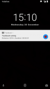
Peek into Trackbook's notification to see the distance and duration of your current recording. Switch to the "Last Tracks" view to review your last recordings. Trackbook stores up to 25 recent tracks. Pull up the statistics to see distance and duration of that recording, as well as the steps taken.
+ GPX Export
Saved recordings can be exported as GPX (GPS Exchange Format) from the "Last Tracks" view. Just tap the export icon next to the track selection menu.
+ How does Trackbook measure distance?
Trackbook calculates the distance between markers and adds them up.
WHICH PERMISSIONS DOES TRACKBOOK NEED?
+ Permission "INTERNET"
Trackbook needs to download map data from OpenStreetMap servers and therefore needs access to the internet.
+ Permission "ACCESS_NETWORK_STATE" and "ACCESS_WIFI_STATE"
Trackbook uses osmdroid to draw its maps. osmdroid needs to know the current state of your device’s connectivity.
+ Permission "ACCESS_COARSE_LOCATION" and "ACCESS_FINE_LOCATION"
Trackbook needs accurate GPS location data to be able to record your movements. If the GPS data is not available or not accurate enough Trackbook uses location data from cell tower and WiFi triangulation.
+ Permission "WRITE_EXTERNAL_STORAGE"
Trackbook uses osmdroid, which caches map tiles on Android's external storage. You can find the map cache in the "osmdroid" folder on the top level of the user-facing file system.
Trackbook adalah tulang aplikasi telanjang untuk merekam gerakan Anda. Trackbook sangat bagus untuk hiking, liburan atau latihan. Setelah memulai jejak gerakan Anda pada peta. Data peta disediakan oleh OpenStreetMap (OSM).
Trackbook adalah perangkat lunak bebas. Anda dapat menemukan kode pada GitHub (https://github.com/y20k/trackbook). GitHub juga merupakan tempat yang baik untuk mengajukan bug atau bahkan untuk berkontribusi, jika Anda tertarik. Trackbook diterbitkan di bawah lisensi open source MIT. Trackbook menggunakan osmdroid untuk menampilkan peta, yang juga perangkat lunak bebas yang diterbitkan di bawah Lisensi Apache.
CARA PAKAI TRACKBOOK
+ Mulai gerakan perekaman
Tekan tombol biru besar untuk mulai merekam gerakan Anda. Trackbook akan terus turun penanda ke peta.
+ Gerakan Berhenti merekam
Untuk menghentikan tekan rekaman Anda tombol biru besar lagi atau menggunakan tombol stop dalam pemberitahuan Trackbook ini. Anda dapat melihat gerakan direkam pada peta sesudahnya.
+ Simpan rekaman terakhir
Menghentikan perekaman dan kemudian tekan lagi tombol biru besar. Ini akan menawarkan pilihan untuk "Simpan dan Clear". toko Trackbook disimpan rekaman sebagai file JSON plaintext di /Android/data/org.y20k.trackbook/files/tracks direktori.
+ Peta utama Batal
Menghentikan perekaman dan kemudian tekan lagi tombol biru besar. Memilih opsi "Clear", jika Anda hanya ingin menghapus peta tanpa menyimpan rekaman Anda.
+ Statistik dan Trek terakhir
Mengintip ke pemberitahuan Trackbook untuk melihat jarak dan durasi rekaman Anda saat ini. Beralih ke "Trek terakhir" pandangan untuk meninjau rekaman terakhir Anda. Trackbook menyimpan hingga 25 lagu baru-baru ini. Tarik statistik untuk melihat jarak dan durasi rekaman itu, serta langkah-langkah yang diambil.
+ GPX Ekspor
rekaman disimpan dapat diekspor sebagai GPX (GPS Efek Format) dari "Trek terakhir" pandangan. Hanya tekan ikon ekspor sebelah menu lagu pilihan.
+ Bagaimana Trackbook mengukur jarak?
Trackbook menghitung jarak antara spidol dan menambahkan mereka.
YANG Perizinan TIDAK PERLU TRACKBOOK?
+ Izin "INTERNET"
Trackbook perlu men-download data peta dari server OpenStreetMap dan karena itu membutuhkan akses ke internet.
+ Izin "ACCESS_NETWORK_STATE" dan "ACCESS_WIFI_STATE"
Trackbook menggunakan osmdroid untuk menggambar peta nya. osmdroid perlu mengetahui keadaan saat konektivitas perangkat Anda.
+ Izin "ACCESS_COARSE_LOCATION" dan "ACCESS_FINE_LOCATION"
Trackbook membutuhkan data lokasi GPS yang akurat untuk dapat merekam gerakan Anda. Jika data GPS tidak tersedia atau tidak cukup akurat Trackbook menggunakan data lokasi dari menara sel dan triangulasi WiFi.
+ Izin "WRITE_EXTERNAL_STORAGE"
Trackbook menggunakan osmdroid, yang cache ubin peta pada penyimpanan eksternal Android. Anda dapat menemukan cache peta di folder "osmdroid" di tingkat atas dari sistem file yang dihadapi pengguna.
Trackbook GPS - Versi 1.1.12
(10-11-2018)
Trackbook GPS - Informasi APK
Versi APK: 1.1.12Paket: org.y20k.trackbookVersi Terakhir dari Trackbook GPS


Aplikasi pada kategori yang sama

Anda juga mungkin suka...
Aplikasi pada kategori yang sama


